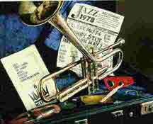
" A 22 piece jazz ensemble that knows how to really cook"
![]()
![]()
![]()
![]()
![]()
![]()
![]()
|
" A 22 piece jazz ensemble that knows how to really cook"
|
|
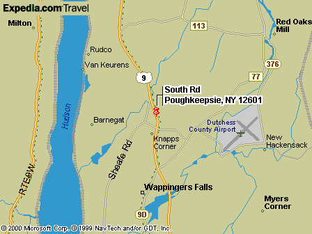
Directions Click on the link below to find directions to our events All directions from IBM Pougkeepsie, South Road, NY
Media Play South-Hills Mall Route 9 South-Hills Mall Road. 2 Miles south of IBM Poughkeepsie south road. Samuel F. B. Morse Historic Site by car... Town of Newburgh Cronomer Park / Baseball Field From RTE. 84 Take exit 7N (Route 300 North). Go to first traffic light and turn right onto Meadow Ave. ( This corner has two banks, a Mobil station and a stop and shop.) Follow Meadow Ave. thru next light. Road becomes Powder Mill Road. Field is 1/2 mile down on the left. Parking for band vehicles is behind the baseball field in the VIP section. Sycamore Park Mahopac From RTE. 84 Take Rte. 84 east to Exit 19. End of ramp make a right onto Rte. 312 to traffic light. Make right onto Rte. 6. Take route 6 all the way to the intersection of 52 and Rte. 6. Make a left onto the continuation of Rte. 6. The lake will now be on your right. Follow Rte. 6 around the lake and pass the water station on your right. Go a little bit farther down the road and make a right onto Crane Road. Follow crane road as it bears to the left you will pass a Fire Dept. on your left. Keep going till you see a sign for Sycamore Park on your left. Use the first driveway to the park to go to the parking area. The Band is playing a little bit up the hill from the lot on the racquet ball court.
Tymor Park Town of Union Vale From Taconic State Parkway: Take the exit for 55 W from the Taconic. Travel on 55 till you reach an intersection with a light. Turn left onto the intersection 21 and follow for a few miles. The park is on the right. Take the road called Tymor park road on your right. Follow into the park. Parking is on your right. Approx. 9 mi. north on route 9. 1/4 mile north of Video Treats, entrance
on left between two stone columns. Approx. 8 miles south on Route 9. Left at intersection of Route 9 and
Route 52. 3 miles east on Rt.52. Entrance just be fore I-84 overpass alongside
Central Hudson. Approx. 4 miles south on Route 9 to light at Meyers Corners Road. Left
onto Meyers Corners Road for 2-1/2 miles on right at intersection of Meyers
Corners Road and All Angels Hill Road. 1/4 mile north onto Spackenkill Road. Going west 4 miles to intersection
of Spackenkill and Vassar Roads. Left onto Vassar Road for approx. 1/2 mile.
Entrance on right. 1/4 mile north onto Spackenkill Road. Going west 4 miles to intersection
of Spackenkill and Vassar Roads. Left onto Vassar Road for approx. 3 miles to
Hooker Ave. .1 mile on Hooker Ave, take second light after passing park to enter
off-street parking. Go south approx. 3 miles to 1st right after Dairy Queen ( East/West Main
Street ) 1/2 mile to Gazebo. Free municipal parking 2 lights past park bearing
left into village. Turn right at light ,parking lot one-half block on right. Printable version Use Adobe Acrobat to view and
print the file:
|
|
Send mail to Webmaster with
questions or comments about this web site.
|